
Foliage Retention Models
Models
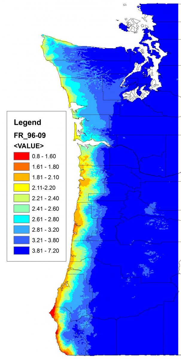
Zhao, Maguire & Mainwaring (2011)
1. Coop & Stone (Version IV, April 2008)
-
Douglas Fir: Swiss Needle Cast Risk Model
-
For information on model parameters, development & GIS files, see http://uspest.org/snc/
-
Zipped GIS files for use with ArcCatalog and ArcMap (ArcGIS)
-
Open "Coop_Fol_Ret.mxd" for a template foliage retention map project in ArcMap that includes all associated files. Because the files will be located in a unique location (directory) on your computer that differs from the location where the project was created, it may be necessary to "re-path" each layer in ArcMap to establish proper links. For instructions, see How to Re-Path Layers below.
-
Cat_ID is the foliage retention variable. Foliage retention values range from 12 to 39, which correspond to 1.2 to 3.9 years of foliage retention. These details are described in the metadata on the model website.
-
This model was developed using the program GRASS. Raster files have been converted to shapefiles so that layers are compatible with ArcGIS software. If you are more familiar with GRASS, GIS files can be downloaded via GRASSLinks from the model website.
-
Geographic Coordinate System: GCS_North_American_1983
-
Datum: D_North_American_1983
-
2. Latta et al. (Unpublished, Submitted April 2010):
-
Western Oregon Douglas-fir Foliage Retention Model
-
Description of model parameters and development (SNCC 2009 Annual Report, "Mapping Western Oregon Douglas-fir Foliage Retention with Spatial Autoregressive Model")
-
Zipped GIS files for use with ArcCatalog and ArcMap (ArcGIS)
-
Open "Greg_Latta_Disc_Handout", then open "2009 Needle Retention Map"
-
In the "Maps" folder, open "Latta_NR_Map_1.mxd" for a template project in ArcMap that includes all associated files. It will be possible to manipulate this project to meet your needs (insert stand waypoints, rescale foliage retention variables, etc.). It may be necessary to re-path layers. For instructions, see How to Re-Path Layers below.
-
Note that there is no projection (.prj) file assigned to the raster files. Importing the ORWA_Counties shapefile before importing the raster files (basenrmap, for_basenr, contour_nr_f2009) will ensure that they are projected properly. The txt file "SNCC_Dec2009_Maps_ReadMe" in the "Greg_Latta_disk_handout" folder describes the type of data contained in each layer.
-
This model was constructed using raster datasets (30x30m pixels) and is most appropriate for fine-scale foliage retention modelling. High-resolution variability in needle retention is observed when you zoom in to the stand-level.
-
Geographic Coordinate System: GCS_WGS_1984
-
Datum: D_WGS_1984
-

3. Zhao, Maguire & Mainwaring (Unpublished, Submitted April 2011):
-
Journal of Forest Ecology & Management (in review): Regional and annual trend in Douglas-fir foliage retention: correlations with climatic variables
-
Foliage Retention Model contains the following:
-
Predicted mean foliage retention 1996 to 2009
-
Predicted mean foliage retention 2010
-
Predicted mean foliage retention 2020 based on several climate change scenarios
-
-
The word file (.docx) "read me" in the "FR_Zhao&Maguire&Mainwaring" folder describes the type of data contained in each layer and the source of the climate data.
-
Zipped GIS files for use with ArcCatalog and ArcMap (ArcGIS)
-
Open "Fol_Ret_Zhao_et_al_2011", then open "GIS_layers_FR_Zhao&Maguire&Mainwaring"
-
In this folder, open "FR_Zhao&Maguire&Mainwaring.mxd" for a template project in ArcMap that includes all associated files. It will be possible to manipulate this project to meet your needs (insert stand waypoints, rescale foliage retention variables, etc.). It may be necessary to re-path layers. For instructions, see How to Re-Path Layers below.
-
Note that there is no projection (.prj) file assigned to the raster files. Importing the ORWA_Counties shapefile before importing the raster files will ensure that they are projected properly.
-
This model is unique in that is projects future foliage retention based on several (13) climate scenarios. Like all models, this model should be used with caution, particularly when being used to estimate future foliage retention. Observers have noted that the model seems to predict lower-than-observed foliage retention along the southern Oregon coast around Coos Bay for the periods 1996-2009, and predicts higher-than-observed foliage retention for coastal Oregon in 2010.
-
Geographic Coordinate System: GCS_WGS_1984
-
Datum: D_WGS_1984
-
How to Re-Path Layers
-
Template foliage retention map projects and associated files are available in the zip folders for both models. Because the files will be located in a unique location (directory) on your computer that differs from the location where the projects were created, it may be necessary to "re-path" each layer in ArcMap to establish proper links.
-
To re-path layers, right-click on the layer, then select properties -> source tab -> set data source, and navigate to the appropriate location/directory where the files are stored on your computer, selecting the file of the same name. Repeat until all "broken links" have been fixed. Broken links are denoted by a red exclamation point to the left of each layer in the ArcMap display window.
-
If you choose to construct your own map project, importing files from ArcCatalog, it will not be necessary to re-path layers. In this case, you will need to 1. alter the layer symbology for the raster files (layer properties), and 2. be careful about the order in which GIS layers are imported to ensure that they are displayed/projected properly. This requires more in-depth knowledge of ArcGIS.
4. Introducing NEXANON!
What is it??
NEXANON is an SMC ORGANON-based tree-level growth and yield model Developed by David Hann and the Center for Intensive Planted-forest Silviculture (CIPS) at Oregon State University. It differs from the the SMC ORGANON model only when projecting stands with Swiss needle cast. NEXANON source code includes a method of accounting for tree height and height increment in SNC-infected stands that helps keep growth loss estimates consistent between tree-level projections and the stand-level analysis.
Downloading NEXANON:
There are essentially two component parts that need to be downloaded: a zipfile containing the NEXANON source code and accompanying files, and the raster data. There is also a short pdf with tips on configuring R and the necessary R packages.
1. Download the zipfile containing the NEXANON user's manual, source codes, DLL files, and R packages here: NEXANON
2. Notes on downloading NEXANON and packages in R can be found here: Notes on NEXANON
3. The raster files used to estimate Swiss needle cast are prohibitively large (collectively ~3GB) to be download directly from the SNCC website. To obtain these files, please contact the Swiss Needle Cast Cooperative (contact info below). Note that NEXANON can estimate Swiss needle cast without the raster files but only by manually inputting foliage retention.
Adam Carson
541-737-3826